Peace Bridge: Border Crossing (Fort Erie) Webcam


Webcam Location
Peace Bridge: Border Crossing
The Peace Bridge at the Fort Erie border crossing is one of the most important gateways between Canada and the United States, linking the town of Fort Erie, Ontario, with the city of Buffalo, New York across the Niagara River. Opened in 1927 and stretching roughly 1.8 kilometers (1.1 miles), it carries both vehicle and pedestrian traffic and remains one of the busiest international crossings in the Great Lakes region. The bridge channels millions of travelers and commercial trucks every year, serving as a vital corridor for tourism, trade, and daily cross-border commuting. On the Canadian side it connects directly to the Queen Elizabeth Way (QEW), while the American side leads immediately to I-190, making it a fast and efficient route into both countries. Crossing the span offers wide views of the Niagara River, the Buffalo skyline, and Fort Erie’s waterfront area. Both ends of the bridge host modern customs and immigration facilities that inspect private vehicles, buses, and freight shipments. Thanks to its strategic location and continuous flow of international traffic, the Peace Bridge remains a critical transportation link between southern Ontario and the northeastern United States.
Bridge - Canada Bound
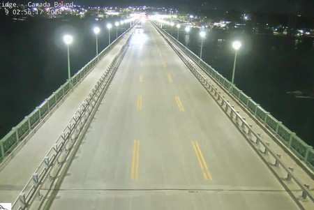
This webcam looks directly toward the span of the Peace Bridge as vehicles travel from Buffalo into Fort Erie, offering a wide, elevated view of Canada-bound traffic. From this vantage point you can see how many lanes are filled on the bridge, how steady the flow of vehicles is, and whether traffic is moving smoothly toward the Canadian inspection area. The camera often captures long lines of cars during peak hours, along with the Niagara River and approaching bridge structure in the background. It's the best overall feed for checking the real-time rhythm of cross-border movement heading into Canada.
